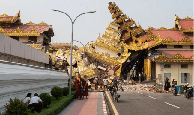
On Friday, 28 March 2025, at 12:50 local time, an earthquake occurred about 17 kilometers from the city of Mandalay, in the Sagaing region of Myanmar. The 7.7 Momentum Magnitude Scale (Mw) earthquake has caused several victims (over 1700 as of today, 30 March 2025) and damages to the built environment. The Momentum Magnitude Scale (Mw) is calculated by combining the values related to the distance the fault line has moved and the force that moved it. To better understand what this means and what happened in Myanmar, let’s make a step back, and explain a few important things
Myanmar lies close to the border of two major tectonic plates, the India and Eurasia plates, which are ‘sections’ of the earth crusts subject to movements. These plates have different types of boundaries, thus they can be convergent, divergent, or transformative (Picture 1).
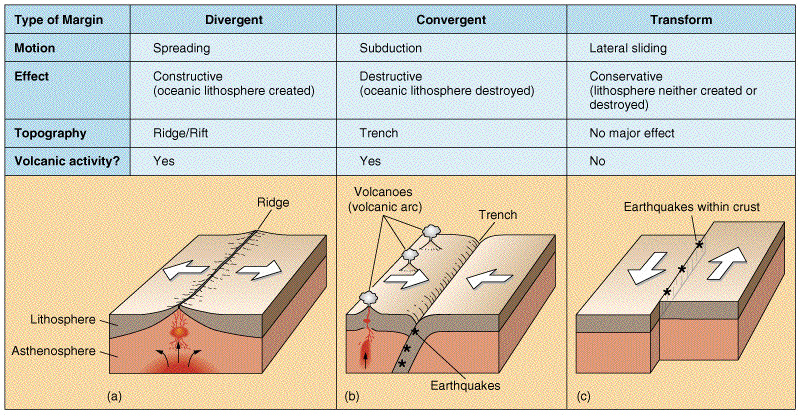
The India and Eurasia plates have moved past each other horizontally. The region is indeed highly seismic considering the presence of several fault lines. The latter are ‘cracks’ in the earth’s crust that can produce movement; these ‘crucks’ are as big as the boundaries between tectonic plates, or small, like the Sagaing fault also responsible for Friday’s earthquake. Indeed, the epicenter of the earthquake occurred in the city of Mandalay which sits on the Sagaing fault. What has likely caused the earthquake was the fact that while sliding along each other, the two blocks on the sides of the Sagaing fault, they got stuck, built friction, accumulated energy, and released in with the 7.7 Mw earthquake (Picture 2).

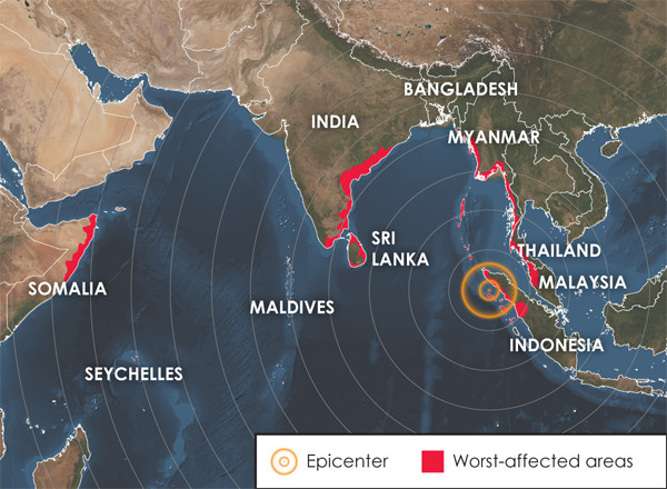
An important aspect to highlight here is the depth at which an earthquake originates below the surface. The less deep, the more powerful the earthquake can be in terms of impact over the built environment. Friday’s earthquake originated at a very shallow depth, 10 kilometers, which also explains the force over the built environment, the damages and consequent death toll. For context, earthquakes can originate as deep as 700 kilometers under the surface, which shows how shallow 10 kilometers is, in perspective. Furthermore, an earthquake energy is not only released circularly around its epicenter, is also released along the fault line. This also explains why a city distant 1000 kilometers from the epicenter, like Bangkok, has experienced the effects of Friday’s earthquake.
Another factor that plays a role in the type of damage caused to the built environment by an earthquake, is the kind of soil that the earthquake’s energy finds: If the soil is soft, the seismic waves originating from the earthquake’s energy release, may slow down, build up, and grow in size, making them potentially more destructive. This, once again, may explain why the earthquake has been felt in Bangkok where the soil tends to be soft (Picture 3).

Moreover, the way in which infrastructures are built, makes them more or less vulnerable to the effects of natural hazards, including earthquakes. For example, seismic-resistant buildings, such as those we often see oscillating in Japan (affected by an earthquake, on average, every eight hours) are suitable to be built in areas at risk of seismic activity. Additionally, according to Dr. Christian Málaga-Chuquitaype from the Imperial College of London, the building under construction in Bangkok that we have seen collapsing in the news, appeared to be a ‘flat slab’ type of structure, considered not suitable anymore to be built in seismic-prone areas.
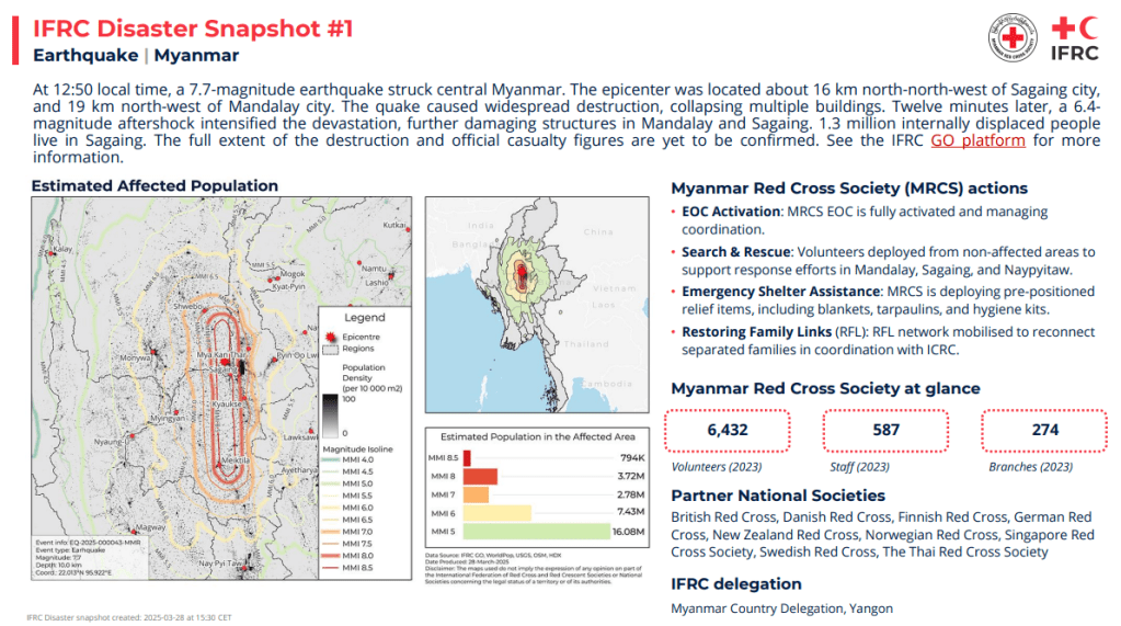
However, these considerations are easy to make on paper, but building seismic-resistant infrastructures requires time and resources. The area affected by Friday’s earthquake was also the one affected by the historic 2004 Indian Ocean Tsunamis. Thus, this type of hazard has received lots of attention and resources thereafter, making the area likely to be more prepared for a tsunami (whose causes, among others, are earthquakes occurring near or below the ocean floor) rather than an earthquake threat (Picture 4).
It is still early to fully understand the impact this event has had on the affected communities, and it is early to talk about lessons learned and future directions for mitigating the seismic risk in the region (Picture 5). It is important though, to understand the science behind, in this case, earthquakes, to inform policy and planning while stressing the importance of not underestimating preparedness in areas where the human memory cannot recall devastating events…like Friday’s earthquake.
Sara Belligoni
Featured Image Credits: Photograph EPA via The Guardian
Sources:
https://www.bbc.com/news/articles/crlxlxd7882o
https://www.bbc.com/news/articles/c8d4dn18nzgo
https://terremoti.ingv.it/en/event/42162362
https://earthquake.usgs.gov/earthquakes/eventpage/us7000pn9s/executive
https://reliefweb.int/map/myanmar/myanmar-77-m-earthquake-dg-echo-daily-map-28032025

You must be logged in to post a comment.